Collaborative Git Workflows
Module 1 - GIST 604B
Professional Collaboration Using GitHub Web Interface
No command line required—learn through point-and-click
The Collaborative Git Workflow
🔄 Five Key Steps:
2. COMMIT What is a Commit?
A commit is a snapshot of your project at a point in time
- Saves your changes
Records what you've done to the repository - Has a unique ID
Every commit gets a unique hash (likea3f82b1) - Includes a message
Describes what changed and why - Points to parent
Creates history chain back to first commit - Permanent record
Can't be changed once created (only added to)
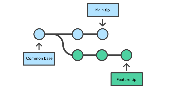
1. BRANCH What is a Branch?
A branch is a pointer to a commit
- Points to a specific commit
The "tip" of the branch - Grows by adding commits
Each new commit moves the tip forward - Diverges from main
Your changes isolated from stable code - Linear history
Each commit points back to its parent, all the way to the first commit
1. BRANCH Branch Naming Conventions
feature/add-postgis-layerNew functionality
fix/coordinate-precision-bugBug fixes
docs/update-installationDocumentation updates
1. Click the branch dropdown (shows "main")
2. Type your new branch name:
feature/add-spatial-query3. Click "Create branch: feature/add-spatial-query"
4. You're now on your new branch—ready to edit files!
2. COMMIT Making Good Commits
A commit is a snapshot of your work
Good Commit Messages:
Fix coordinate precision bug in buffer calculationExplains what and why
Poor Commit Messages:
Update codeToo vague
Fix bugWhich bug?
WIPNot descriptive
• Make atomic commits (one logical change)
• Commit often (small, focused changes)
• Write present-tense messages ("Add" not "Added")
• Think: "This commit will..." [your message]
3. PULL REQUEST What is a Pull Request?
A pull request (PR) is a proposal to merge your branch into another branch
- Proposes changes
"I've finished my work, please review and merge it" - Opens discussion
Team can review, comment, and suggest improvements - Shows differences
GitHub displays exactly what changed between branches - Tracks conversation
All feedback, questions, and decisions in one place - Gateway to merge
After approval, changes can be merged into main branch
3. PULL REQUEST Anatomy of a Good Pull Request
"Add support for GeoJSON export in QGIS plugin"
## Description
Adds CSV export functionality to spatial analysis results

## Motivation
Users requested ability to export for Excel (#42)

## Changes
- Added export_to_csv() function in utils.py
- Updated UI with "Export" button
- Added tests for CSV generation
- Updated README with export documentation

## Testing
- Manual testing with sample datasets
- All existing tests pass
- New tests added for CSV export
Good PRs get merged; poor PRs get ignored
3. PULL REQUEST Pull Request Best Practices
- 📝 Clear Title: Descriptive and specific
Good: "Add GeoJSON export" | Bad: "Update code" - 📋 Detailed Description: What, why, how, testing
Help reviewers understand your changes - 🎯 Small, Focused Changes: One PR = one feature
Easier to review = faster to merge - ✨ Clean Commit History: Logical, atomic commits
Tell a story of development - 🖼️ Screenshots: If UI changes
Visual confirmation helps reviewers
4. REVIEW Why Review My Pull Request?
Even solo projects benefit from the review process
For Solo Projects:
- Catch mistakes
Fresh eyes spot bugs you missed - Improve code quality
Get suggestions for better approaches - Learn best practices
Reviewers share their expertise - Document decisions
PR discussion explains "why"
For Team Projects:
- Keep everyone aligned
Team knows where project is going - Maintain consistency
Naming conventions, code style - Share knowledge
Everyone learns how the code works - Prevent conflicts
Catch issues before they're merged
4. REVIEW Code Review Best Practices
As a Reviewer:
- ✅ Be respectful and constructive
- ✅ Focus on code, not person
- ✅ Explain "why" when requesting changes
- ✅ Acknowledge good work
- ✅ Suggest alternatives, don't just criticize
- ✅ Review promptly (contributors are waiting)
"Nice work on the spatial indexing! One suggestion: Consider using R-tree instead of quad-tree here for better performance with dense point clouds. See: [link to documentation]"
"This is wrong. Change it."
4. REVIEW Receiving Code Review
As a Contributor:
- ✅ Don't take feedback personally
- ✅ Ask questions if unclear
- ✅ Discuss trade-offs professionally
- ✅ Iterate based on feedback
- ✅ Say thank you for thorough reviews
Every reviewer was once a beginner receiving feedback.
Professional developers welcome constructive feedback
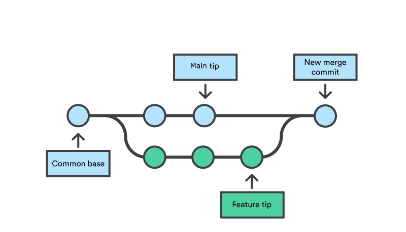
5. MERGE What is Merging?
Merging integrates changes from one branch into another
- Combines work
Brings your feature branch changes into main - Preserves history
Both branches' commits remain in the history - Creates merge commit
Special commit that joins two branches together
Two Possible Outcomes:
- Git automatically combines changes
- No overlapping edits
- Different files modified
- Different parts of same file
- Result: Instant merge ✨
- Both branches changed same lines
- Git can't automatically decide
- Conflicting edits to code
- Human decision required
- Result: Manual resolution needed 🛠️
5. MERGE Understanding Merge Conflicts
🤔 What Are Merge Conflicts?
- Two people edited the same lines of code
- Git can't automatically merge
- You must manually decide which changes to keep
You're working on feature branch → Meanwhile, main branch updated → Your branch now conflicts with main
💡 The Good News: Conflicts are normal! Resolution is a learned skill.
5. MERGE Resolving Merge Conflicts (Web UI)
GitHub opens web-based conflict editor
<<<<<<< your-feature-branch (your changes)
result = calculate_distance(point1, point2)
=======
result = compute_spatial_distance(point1, point2)
>>>>>>> main (their changes)
• Delete conflict markers (
<<<<<<<, =======, >>>>>>>)• Keep your changes, their changes, or blend both
• Result:
result = compute_spatial_distance(point1, point2)
5. Commit merge: Click "Commit merge" button
✅ Conflict resolved! PR can now be merged
5. MERGE Preventing Merge Conflicts
- 🔄 Sync with main frequently
Don't let your branch drift too far - ⚡ Keep branches short-lived
Merge quickly, don't leave branches open for weeks - 💬 Communicate with team
"I'm working on the auth module" - 🎯 Small, focused changes
Smaller PRs = fewer conflicts - 👥 Divide work clearly
Different developers, different files when possible
Prevention is easier than resolution!
Assignment: M1A4
Practice Collaborative Workflows
What You'll Do (All in GitHub Web UI):
- Work with a partner on a shared repository
- Create feature branches for your changes
- Make meaningful GIS-related edits using web editor
- Create pull requests with clear descriptions
- Review your partner's pull requests with constructive feedback
- Experience and resolve merge conflicts together
Learning Goals (Real Collaboration!):
- 🤝 Collaborate effectively - coordinate changes with a teammate
- 🌿 Branch management - create and work in isolated branches
- 💬 Communication - write clear PRs and give helpful feedback
- 🔀 Merging experience - integrate changes and handle conflicts
- 🛠️ Conflict resolution - resolve overlapping edits together
🎯 Focus: Learn collaboration, merging, and conflict resolution through hands-on practice!
Essential Resources
- GitHub Flow
- GitHub Pull Requests Guide
- Resolving Conflicts (Web UI)
- How to Contribute to Open Source
- GitHub Desktop (GUI app)
- VSCode Git integration
- Command line (not needed for this course)
- First Contributions
- Good First Issues in GIS projects
- M1A4 assignment (web UI practice)
💡 Focus on GitHub's web interface first—it's all you need to contribute!
Key Takeaways
- ✅ Collaborative workflows enable quality code at scale
- ✅ Branches isolate work; PRs propose changes
- ✅ GitHub web UI makes these workflows accessible
- ✅ Good PRs are clear, focused, and well-tested
- ✅ Code review is collaborative teaching
- ✅ Merge conflicts are normal—web UI makes resolution easier
- ✅ This is how you contribute to open source
These are job-ready skills
By completing M1A4 (100% web UI), you'll know professional Git workflows
used by developers worldwide—no command line needed!
Ready to collaborate? Let's practice in M1A4!
Add support for GeoJSON exportClear, specific, action-oriented